Showing posts with label Inca's. Show all posts

Saturday, 31 May 2014

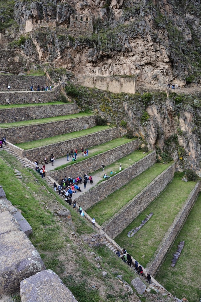
Ollantaytambo defense fortress saves Machu Picchu from the conquistadors

What an amazing Inca site Ollantaytambo has. The terraces had an agricultural function like everywhere in Peru. This major complex had mainly a religious function and has never been completed. This is visible at the back of the mountain where we still see a handmade ramp to pull large rocks up the mountain.

We liked this site so much because of its beautiful ruins and hiking trails. It is just fantastic to look down on the terraces and walk on the narrow dirt paths. In the lower part of the Inca complex there are still a few temples with streaming water.

Due to the steep terraces and being surrounded by mountains, this Inca site had a strategic defense location. The Spanish conquistadors had heard of the Inca city of Machu Picchu and were going to destroy it like all the others. To reach Machu Picchu, just like today, you have to pass via Ollantaytambo.

The last Inca King Manco blocked the access road to Machu Picchu via this fortress, it has hidden for the invaders. They had two choices, defeat the Inca's at Ollantaytambo by taking the fortress or continue their search for Machu Picchu going east or west alongside Ollantaytambo. After a long fight and several defeats this is what they did.

Continuing alongside the Urubamba River they could not see Machu Picchu hidden behind the trees of the tropical forest in the mountains. Making their way to the right, through the jungle, most conquistadors got sick and died. Their biggest weakness was getting ill from the altitude. A whole Spanish regiment searched 34 years for Machu Picchu and couldn't find it. Eventually Ollantaytambo fell but today’s most famous Inca city Machu Picchu was never discovered by the colonists.

Wat een verbluffend Inka complex vinden we hier in Ollantaytambo. De terrassen hebben een landbouwfunctie net zoals overal in Peru. Oorspronkelijk was dit een religieuze plaats maar deze werd nooit volledig afgewerkt. Dit is zichtbaar aan de achterkant van de berg waar nog een man gemaakte helling ligt voor het naar boven trekken van bouwstenen.

Deze site trok ons zeer sterk aan vanwege de mooie ruïnes en wandelpaden. Het is gewoon fantastisch het complex beneden te zien van op een smal aarde pad. In het lager gelegen gedeelte van het complex staan nog enkele tempels met stromend water.

Door de steile terrassen omringt door bergen was deze Inka site een strategische verdedigingsplaats. De Spaanse veroveraars hadden gehoord over Machu Picchu en gingen ook deze stad vernietigen zoals alle andere. Net zoals vandaag, moest men via Ollantaytambo passeren vooraleer Machu Picchu te bereiken.

De laatste Inka koning Manco blokkeerde de weg naar Machu Picchu met deze vestiging, de stad was verborgen voor de invallers. Ze hadden twee keuzes om Machu Picchu te bereiken, via de linker en rechter zijde van Ollantaytambo. Na een lang gevecht gingen ze inderdaad verder langs beide wegen. 

Hun weg makende via de Urubamba Rivier konden ze Machu Picchu niet zien dat verborgen lag in de bergen achter bomen van het tropische regenwoud. Langs rechts moest men door het oerwoud en de meeste Spanjaarden lieten het leven. Hun grote zwakte was hoogteziekte. Het Spaanse regiment zocht 34 jaar in het oerwoud en kon Machu Picchu niet vinden. Later viel Ollantaytambo toch onder de aanvallen maar de meest beroemde Inka Site ter wereld, Machu Picchu werd nooit gevonden door de kolonisten. 
 
Ollantaytambo Inca Site

Ollantaytambo Inca Site

Ollantaytambo Inca Site

Ollantaytambo Inca Site

Ollantaytambo Inca Site

Ollantaytambo Inca Site

Ollantaytambo Inca Site

Ollantaytambo Inca Site

Ollantaytambo Inca Site

Ollantaytambo Inca Site

Ollantaytambo Inca Site

Ollantaytambo Inca Site

Ollantaytambo Inca Site

Ollantaytambo Inca Site

Ollantaytambo Inca Site

Ollantaytambo Inca Site

Previous Ollantaytambo article: Ollantaytambo town, one of the oldest cities of South America

Previous Temple article: The Inca IntihuatanaTemple of Sacred Valley

Return to main page

Monday, 26 May 2014

The Inca IntihuatanaTemple of Sacred Valley

Astronomy was one of the specialties of the Inca's, you find information back on this at every temple. Here at the Intihuatana ruins is the Temple of the Sun located. Inca scientists measured the position of the sun continuously and were able to place their cities and agricultural terraces in ideal positions.

On this mountain, at an altitude of around 4.200 meters we found many hiking trails with spectacular views of the temples and valley. Flowers were blossoming, small streams of water came from the mountains increasing the water reserves of the ancient Inca complex. A group of people were dancing to celebrate a local festival. They didn't have any physical problem to dance for a long time at this altitude.

We also adjusted to the altitude after a few days. It was fun, our guide stopped about half a kilometer from the top because all the group members needed rest. We were still in good shape and had to reach the top. We went on, running up the hiking trails to the summit. Our multiple sports sessions a week paid off.

On one of the pictures you see a close up of the mountain with holes in the rocks. These are all Inca graves. Deceased were put into these man made caves to be closer to Mother Earth, become one with nature again. Some of their possessions were also put in there. It was generally expected they would need these in the afterlife. This is the main reason why most of the 3.000 tombs were opened during the colonial period in search for gold.

Astronomie was één van de specialiteiten van de Inka's, je vindt hierover informatie aan bijna elke tempel. Hier aan de Intihuatana ruïnes vind je de Tempel van de Zon. Inka wetenschappers registreerden continu de standen van de zon en waren in staat hun huizen en landbouwgronden strategisch te plaatsen in ideale posities.

Op de berg, op een hoogte van ongeveer 4.200 meter vonden we vele wandelpaden met spectaculaire zichten op de tempels en valleien. De bloemen stonden in volle bloei, beekjes water stroomden van de bergen de waterreserves van het antieke Inka dorp vullende. Een groep mensen van Pisac dansten voortdurend vanwege lokale festiviteiten. Zij hadden geen enkel probleem met de hoogte.

Wij waren na enkele dagen Peru ook al aan de hoogte aangepast. Het was gewoon grappig, de gids stopte ongeveer een halve kilometer van de top omdat de groep niet meer verder kon. Wij waren nog in goede conditie en renden in hoog tempo over de wandelpaden naar de top. Onze vele sportsessies iedere week hebben toch een grote invloed op onze fysieke mogelijkheden. 

Op één van de foto's zie je een rotswand met gaten. Dit zijn Inka graven. De overledenen werden in deze door de mens gemaakte grotten ingeduwd om dichter bij Moeder Aarde te zijn, het terug één worden met de natuur. Ook sommige bezittingen werden in de graven verborgen. Men dacht dat men deze bezittingen nodig zou hebben in het hiernamaals. Dit is de hoofdreden waarom de meeste van de 3.000 graven werden geschonden tijdens de koloniale periode op zoek naar goud. 
 
Intihuatana Sacred Valley

Intihuatana Sacred Valley

Intihuatana Sacred Valley

Intihuatana Sacred Valley

Intihuatana Sacred Valley

Intihuatana Sacred Valley

Intihuatana Sacred Valley

Intihuatana Sacred Valley

Intihuatana Sacred Valley

Intihuatana Sacred Valley

Intihuatana Sacred Valley

Intihuatana Sacred Valley

Intihuatana Sacred Valley

Intihuatana Sacred Valley

Intihuatana Sacred Valley

Intihuatana Sacred Valley

Previous Pisac article: Pisac food market where exchanging goods is a regular payment method

Previous Temple article: Streaming water of Tambomachay, Cusco

Return to main page

Saturday, 24 May 2014

Views over the Urubamba or Sacred Valley of the Inca's

Down below between the green mountain ranges of the Andes, you see a little village. It is located next to the Urubamba River or the Sacred River, from there the name of the valley is derived. This is one of the most fertile areas of the region and people have been living here for more than six centuries. The houses however still look very primitive.

From our position we just had perfect views of the Sacred Valley. Looking to the horizon, the green lower Andes range makes place for higher mountains which are covered in snow. It was a bit cloudy but the ice was clearly visible. Before we continue our trip we took a moment to admire a small three wheeler car. How funny, could you imagine such a car on the European roads?

Ver beneden tussen de groene bergketens van de Andes zie je een klein dorpje. Het is gebouwd nabij de Urubamba Rivier of de Heilige Rivier, van daar komt ook de naam van de vallei. Het zijn de vruchtbaarste gronden uit de regio en mensen wonen hier reeds meer dan 6 eeuwen. De huizen lijken echter nog heel primitief. 

Van waar wij stonden hadden een perfect zicht over de Heilige Vallei. Als je naar de horizon kijkt zie je de groene lagere Andes versmallen en plaats maken voor hoge bergen die bedekt zijn met sneeuw. Het was er bewolkt maar het witte ijs was duidelijk zichtbaar. Voor dat we met onze trip verder gingen stopten we nog even om een kleine driewieler wagen te bewonderen. Wat leuk, zou je zo'n auto kunnen voorstellen op de Europese wegen? 
 
Urubamba Sacred Valley

Urubamba Sacred Valley

Urubamba Sacred Valley

Urubamba Sacred Valley

Urubamba Sacred Valley

Urubamba Sacred Valley

Urubamba Sacred Valley

Urubamba Sacred Valley

Urubamba Sacred Valley

Urubamba Sacred Valley

Urubamba Sacred Valley

Previous Peru article: Streaming water of Tambomachay, Cusco

Previous Mountain article: Experience the altitude and visit Plaza de Armas, Cusco

Return to main page

Friday, 23 May 2014

Streaming water of Tambomachay, Cusco

A few decades ago we were happy that all our houses or hotels had streaming water. The Inca's already had this a few centuries ago. It is very clear from the Tambomachay architecture in which the streaming water and aquaducts are clearly visible. It was built aproximately 500 years ago.

The Inca's were not only using this technique here but in all their temples, cities and argricultural terraces. Water was streaming all year long from the mountains or higher regions via canals to the living areas of the Inca society. Historians believe Tambomachay had several functions: spa center,resting place for travellers and military defense point for the nearby capital of the Inca's, Cusco.

Enkele tientallen jaren geleden waren wij reeds blij dat al onze huizen en hotels stromend water hadden. De Inka's waren reeds zover ontwikkeld enkele eeuwen terug. Dat is zeer duidelijk aantoonbaar via de architectuur van Tambomachay waar je onmiddellijk het stromend water ziet. Het werd gedurende de 15de eeuw gebouwd. 

De inka's gebruikten deze technieken niet enkel hier maar bij al hun tempels, steden en landbouwterrassen. Het water stroomt het ganse jaar door en komt van de bergen of hoger gelegen gebieden via kanaaltjes naar de woongebieden van de Inka gemeenschap. Geschiedkundigen geloven dat Tambomachay verschillende doelen had: kuuroord, rustplaats voor reizigers en militaire voorpost ter bescherming van de nabij gelegen Inka hoofdstad Cusco. 
 
Tambomachay Temple Cusco

Tambomachay Temple Cusco

Tambomachay Temple Cusco

Tambomachay Temple Cusco

Tambomachay Temple Cusco

Tambomachay Temple Cusco

Tambomachay Temple Cusco

Previous Cusco article: Different kinds of wool in the Perez Factory, Cusco

Previous Temple article: Honor the Gods by sacrifices at the Qenko temple, Cusco

Return to main page